

Miller Cylindrical Projection Distance between Washington D.C. and Kabul: 10,131.25181394 miles
Mercator Projection Distance between Washington D.C. and Kabul: 10,112.13919192 miles

Eckert IV Projection Distance between Washington D.C. and Kabul: 7,835.043849347 miles
Mollweide Projection Distance between Washington D.C. and Kabul: 7,925.573197180 miles
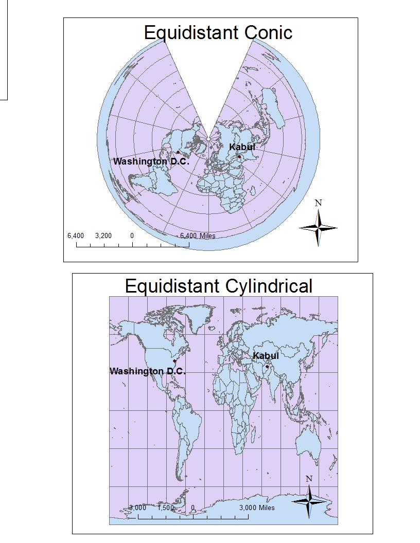
Equidistant Conic Projection Distance between Washington D.C. and Kabul: 6,972.494037703 miles
Equidistant Cylindrical Projection Distance between Washington D.C. and Kabul: 5,061.88690287 miles
Map projections are a tool geographers use to transform the
3-dimensional globe into a 2-dimensional form. It is a process of mathematical
conversion in which the “real” measurements of the Earth must be translated
into “virtual” measurements. The three methods of projections are planar or
azimuthal, cylindrical, or conic. The simplest way to demonstrate the process
of using these methods to make projections is to compare it to translating the
globe onto a piece of paper. The planar projection is when a piece of paper is
held up to one part of the globe and the part where the paper touches is
extremely accurate but the regions that do not touch are distorted. The
cylindrical projection can be described as wrapping a piece of paper around the
globe in the shape of a cylinder. Wherever the map touches the globe, the map
is accurate but the regions above and below the touching paper would be
distorted. Lastly, the conic projection can be described as wrapping and
folding a piece of paper into a cone shape and putting it around the globe like
a hat depending on the angle in which it is held up to the Earth. Three types
of map projections that use these methods are conformal, equidistant, and equal
area.
A conformal
map projection is when the meridians and parallels intersect at right angles.
Another characteristic of the conformal map is that the scale at any point must
be the same in all directions. They preserve local shapes and angles; however
they distort the areas rather significantly as demonstrated above in the
Mercator projection and the Miller Cylindrical projection. This is clearly exhibited
by the comparison of the distance between two points, or cities, as displayed
on the maps. The two points represent Washington D.C. in the United States and
Kabul in Afghanistan. The distance as represented on the Mercator projection
shows it as approximately 10, 112 miles. However, on the Miller Cylinder
projection the distance between the cities is stated as approximately 10,131 miles.
This is not an excessive distance comparing between the two conformal maps, but
when comparing it to other types of projections, there is a significant
discrepancy.
An equal
area projection maintains the same proportional relationships to the areas on
the Earth that they represent. This means that the area of North America is
displayed proportionally accurate in comparison to the areas of Africa and
Europe. Examples of the equal area projection are displayed above in the
Mollweide and Eckert IV projections. However, the distance between two points
is not necessarily maintained in the equal area map projection, as displayed in
the distance between Washington D.C. and Kabul. The distance on the Mollweide
map projection is measured as around 7,926 miles. On the Eckert IV projection,
the distance between the two cities is calculated as about 7,835 miles. Again,
there is not an extreme difference between the distances comparing the two
types of equal area projections, a mere 91 miles. However, when comparing these
distances to other map projections, such as the conformal map projections, the
difference could be over a few thousand miles.
Another
type commonly used is the equidistant map projection. The equidistant map
projection is a projection that maintains scale from one or two points to all
other points on the map. This means that, with the correct scale, the distance
between two points is proportionally accurate. Examples of the equidistant map
projection are displayed above in the Equidistant Conic projection and the
Equidistant Cylindrical projection. The distance between Washington D.C. and
Kabul on the Equidistant Cylindrical projection is measured as about 5,062
miles. On the Equidistant Conic projection, the distance between the two cities
is measured as around 6,972 miles. The “real” distance between Kabul and
Washington D.C. is stated to be around 6,920 miles. (There are different
resources that have different exact measurements.) The Equidistant Conic
projection seems to have the most accurate scale out of all the map projections
to measure the distance between Kabul and Washington D.C. The equidistant projection
has significantly different calculations to the distance between the two points
compared to the conformal and equal area map projections. These examples and relationships
display the importance of using a specific type of map projection in order to
convey the information accurately, as according to the creator, to the audience.
No comments:
Post a Comment